
The GPS isn’t the only navigation by satellite system which exists. This post will show the other navigation systems.
To know how GPS works, click in the button below.
Search for independence
The GPS was created by USA to military use, to know the location of ships, aircrafts, vehicles, missiles, individual soldiers and the trajectory of missiles. Was liberated to civilian use to avoid accidents. The signal can be easily disturbed with a strong radio burst in the same frequency, therefore, can be disabled by the time USA wants, wherever wants. Other countries are building or already have it own satellite constellation.
Glonass (Russia)
![]()
This system is already in operation, has 24 satellites and stays in 19,100 km of altitude. Works better in high latitudes of North Hemisphere. This figure shows the orbit of both constellations.

The Glonass system started in 1982 and has multiple versions.

The first version were to military and official organizations, it is not used anymore. The current version is the Glonass-M, the Glonass-K is in maturation stage and the Glonass-K2 is in development. The used frequencies are: L1OF (1602 MHz), L2OF (1246 MHz) and L3OC (1202 MHz), Glonass-K will add the L2OC (1248 MHz) frequency and K2 the L1OC (1600 MHz). The Google Maps uses both GPS and Glonass.
Galileo (European Union)
![]()
This system is planned to enter in service in 2020. Actually it has 18 satellites in orbit, in 23,222 km of altitude, it is necessary at least 24 satellites to have global range. Will be more precise than the GPS and Glonass.
The Galileo’s constellation.

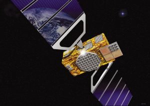
BeiDou (China)

Initially was created to Asia and Oceania, in 2020 will have global range. The red square in the figure below shows the Beidou’s actual range.

This system actually have 21 satellites in orbit and it is planned to have 35, stay in 21,150 km of altitude and your precision is equal of the traditional GPS. Operate in B1 (1561,098 MHz), B2 (1207,14 MHz) and B3 (1268,52 MHz) frequencies. Here are the BeiDou`s satellite and constellation respectively.


Navic or IRNSS (India)
![]()
This is a regional system, has only 7 satellites, but it is enough to indian subcontinent. The satellites stay in geostationary orbit in 36,000 km of altitude and has a precision of 10 meters in the indian subcontinent and 20 meters in the Indian Ocean.


QZSS (Japan)
![]()
Another regional system, the satellites stay in quasi-zenith orbit, that’s why it has this name. In this orbit, which stay in 36,000 km of altitude, the satellite make a trajectory in form of 8 in relation to Earth.

Actually has 4 satellites and it is planned to have 7. Operate in multiple frequencies in L band: L1 (1575,42 MHz), L2 (1227,60 MHz), L5 (1176,45 MHz) and LEX(1278,75 MHz).